Tu Experto GIS, Cuando lo Necesites
Lo Que Hacemos
Soluciones basadas en mapas para organizaciones con presencia territorial
2IT proporciona soluciones de software basadas en mapas para ayudar a organizaciones con presencia territorial a planificar, desarrollar y operar proyectos de manera eficiente, permitiendo una toma de decisiones inteligente, aumentando la productividad y ahorrando recursos a través de una plataforma fácil de usar.
Nuestros
Servicios
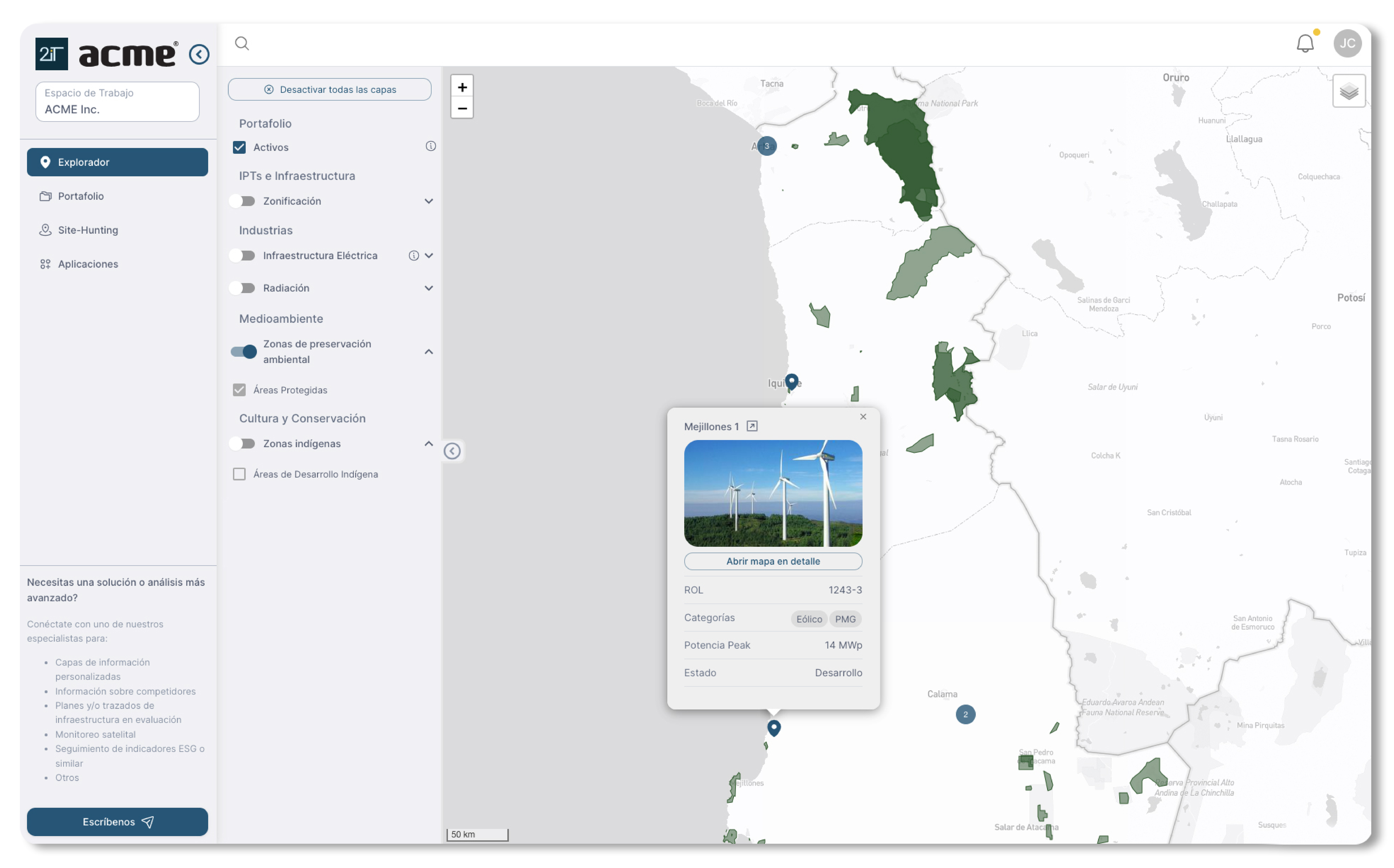
Mapa Explorador
Una herramienta integral para analizar múltiples capas geoespaciales (p. ej., uso del suelo, biodiversidad, zonificación, mercados, demografía, clima y riesgos) para identificar oportunidades de inversión y priorizar áreas de alto potencial.
Gestión de Activos Territoriales
Simplifica la gestión de carteras de activos a través de mapas geoespaciales, KPIs, metadatos y herramientas de visualización de archivos, garantizando un acceso eficiente a los datos y una toma de decisiones informada.
Búsqueda de Sitios
Mejora la toma de decisiones con herramientas geoespaciales para evaluar ubicaciones potenciales de proyectos proporcionando información detallada y métricas para una selección de sitios informada.
Análisis Avanzado
Ayudamos a diferentes industrias a responder preguntas espaciales complejas, como dónde invertir, ubicar una instalación o monitorear territorio, analizando imágenes satelitales y datos espaciales para entregar información de alto impacto y toma de decisiones inteligente.
Integraciones de IA
Nuestras herramientas integran IA para simplificar el análisis espacial, automatizando evaluaciones de sitios, mientras analizan patrones e indicadores, facilitando la evaluación de oportunidades y riesgos con confianza.
Nuestro Producto
Plataforma 2IT
Tu Experto GIS, Cuando lo Necesites

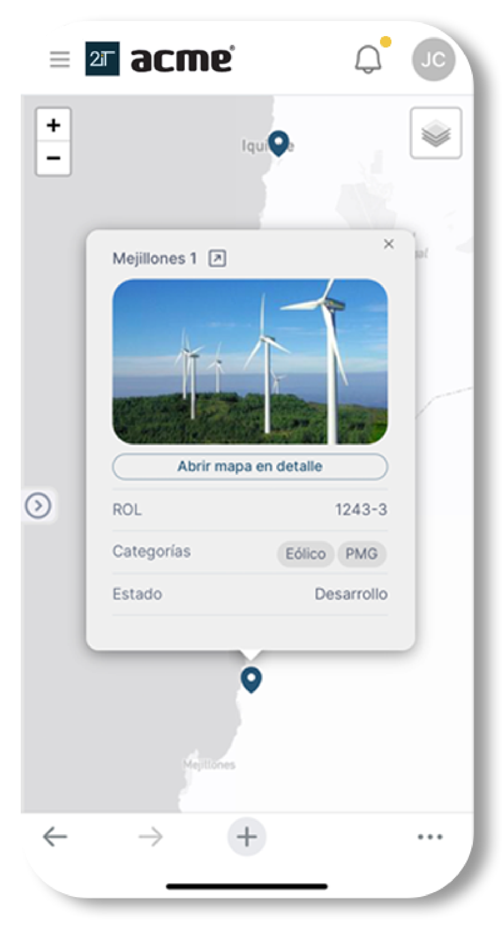
Accesible en cualquier momento y lugar, desde tu teléfono.

Estamos mapeando el futuro con organizaciones líderes
Confiados por empresas de todas las industrias, geografías y tamaños, incluidas aquellas que atienden tanto mercados B2B como B2C.


Nuestro Equipo
Nuestro equipo fundador está compuesto por líderes altamente complementarios y con experiencia global, con experiencia en tecnología, IA, GIS y planificación territorial y urbana.

Juan Pablo Corral
Lidera marketing e innovación de productos geoespaciales, combinando experiencia en GIS con diseño centrado en el usuario para desarrollar herramientas impactantes.
Formación: Arquitectura, Pontificia Universidad Católica de Chile; MSc en Diseño Urbano, London School of Economics.
Expertise: Análisis de datos geoespaciales, mapeo web y soluciones GIS para desafíos urbanos y territoriales.
- Ex-consultor GIS en Felt.com en San Francisco.
- Lideró más de 50 proyectos de GIS / Planificación territorial a nivel internacional.
Contacto: [email protected]

Vicente Opaso
Lidera el desarrollo de productos con habilidades avanzadas en IA, robótica e ingeniería de software, creando soluciones escalables y de vanguardia.
Formación: Ingeniería Civil en Computación, Pontificia Universidad Católica de Chile.
Expertise: Desarrollo de software, IA, Robótica, Cloud, IoT y VR/AR.
- Líder de equipo de software en Levita Magnetics, avanzando en robótica impulsada por IA para tecnología médica en Silicon Valley.
- Creó modelos de IA y visión por computadora en Zippedi para robots de retail inteligentes.
- Desarrolló la primera prótesis de brazo robótico en Chile.
Contacto: [email protected]

Sebastián Salas
Lidera estrategia y asociaciones con experiencia global en proyectos de planificación urbana y territorial, trabajando con gobiernos e instituciones privadas.
Formación: Ingeniería Comercial, Pontificia Universidad Católica de Chile; MSc en Planificación Urbana e Inmobiliaria, Columbia University, NYC.
Expertise: Desarrollo Urbano y Territorial, Inversión ESG, Asociaciones Público-Privadas.
- Consultor para el Banco Interamericano de Desarrollo (BID), HR&A Advisors (NYC), Sanergy (Kenia).
- Profesor en la Pontificia Universidad Católica de Chile, enseñando Estrategias de Regeneración Urbana.
Contacto: [email protected]